 geo.be Metadata Catalog
Planning cadastre
Type of resources
Available actions
Topics
INSPIRE themes
federalThemes
Keywords
Contact for the resource
Provided by
Years
Formats
Representation types
Update frequencies
status
Scale
-

Cadastral parcels - monthly situation corresponds to the dataset of the monthly situation of the cadastral parcels layer from the Land Register plan. The dataset is composed of two classes. The first class contains the geometries of the cadastral parcels; the second is a class without geometry and corresponds to a code table of the different fiscal situations used in the first class. The dataset can be freely downloaded as a zipped shapefiles.
-

Cadastral Parcels - INSPIRE corresponds to the dataset of Belgian plan cadastral parcels complying with INSPIRE specifications. This dataset is composed of two classes. The first class contains cadastral zoning and the second class contains cadastral parcel. The entire dataset can be downloaded via the ad hoc WFS.
-

The Royal Decree of 22 May 2019 establishing a marine spatial plan defines 1 coastal protection experiments zone: Zone for coastal protection experiments (Art. 16§2). It replaces the 2014 Marine Spatial Plan, which is included for completeness. The Royal Decree of 20 March 2014 establishing a marine spatial plan defines in its Art. 12. §1 one zone for coastal protection experiments. This zone is made available digitally in the resource described by this metadata document. Please refer to the Belgian official gazette (\"Moniteur belge/Belgisch Staatsblad\") for official reference information.
-

The Royal Decree of 22 May 2019 establishing a marine spatial plan defines 6 energy, cable and pipeline zones: Area 1 for renewable energy (Eastern zone) (Art. 8§1), Area 2 for renewable energy (Noordhinder North) (Art. 8§2), Area 3 for renewable energy (Noordhinder Zuid) (Art. 8§3), Area for renewable energy - zone 4 (Fairybank) (Art. 8§3), Modular offshore grid for transmission of energy (Art. 8§5), Pipelines and cables corridor (Art. 9§1). It replaces the 2014 Marine Spatial Plan, which is included for completeness. The Royal Decree of 20 March 2014 establishing a marine spatial plan defines in its Art. 9. five dredged material disposal sites (Dredged material disposal site S1, Art. 9 § 6.1°; Dredged material disposal site S2, Art. 9 § 6.2°; Dredged material disposal site Bruggen en Wegen Oostende, Art. 9 § 6.3°; Dredged material disposal site Bruggen en Wegen Zeebrugge Oost, Art. 9 § 6.4°; Dredged material disposal site Bruggen en Wegen Nieuwpoort, Art. 9 § 6.5°). These zones are made available digitally in the resource described by this metadata document. Please refer to the Belgian official gazette (\"Moniteur belge/Belgisch Staatsblad\") for official reference information.
-

The Royal Decree of 22 May 2019 establishing a marine spatial plan defines 5 nature conservation areas: Special area for conservation 'The Flemish Banks' (Art. 7§1), Special area for conservation 'Vlakte van de Raan' (Art. 7§3), Special protection area for birds - SPA 1 (Art. 7§5.1°), Special protection area for birds - SPA 2 (Art. 7§5.2°), Special protection area for birds - SPA 3 (Art. 7§5.3°). It replaces the 2014 Marine Spatial Plan, which is included for completeness. The Royal Decree of 20 March 2014 establishing a marine spatial plan defines in its Art. 7., six nature conservation sites: two special areas for conservation (Art. 7. §1, Special area for conservation 'Vlaamse Banken' and Art. 7. §3, Special area for conservation 'Trapegeer stroombank'), three special protection zones for birds (Art7§4.1°, SBZ1, Art7§4.2°, SBZ2, Art7§4.3°, SBZ3), and one marine reserve (Art7§8, Marine reserve 'Baai van Heist'). These zones are made available digitally in the resource described by this metadata document. Please refer to the Belgian official gazette (\"Moniteur belge/Belgisch Staatsblad\") for official reference information.
-
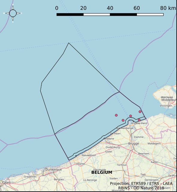
The Royal Decree of 22 May 2019 establishing a marine spatial plan defines 6 measuring poles: Measuring pole MOW.0 (Art. 21§2), Measuring pole MOW.1 (Art. 21§2), Measuring pole MOW.2 (Art. 21§2), Measuring pole MOW.3 (Art. 21§2), Measuring pole MOW.4 (Art. 21§2), Measuring pole Westhinder (Art. 21§2). It replaces the 2014 Marine Spatial Plan, which is included for completeness. The Royal Decree of 20 March 2014 establishing a marine spatial plan defines in its Art. 15. §3, one set of measuring pole locations. These locations are made available digitally in the resource described by this metadata document. Please refer to the Belgian official gazette (\"Moniteur belge/Belgisch Staatsblad\") for official reference information.
-
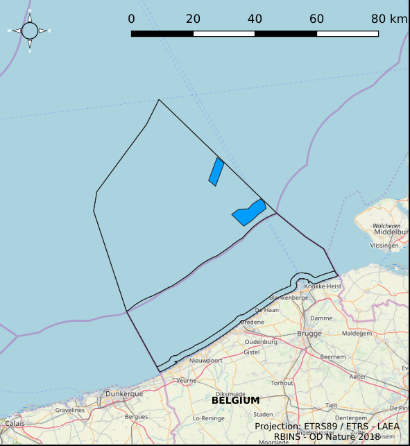
The Royal Decree of 22 May 2019 establishing a marine spatial plan defines 4 aquaculture zones: Zone 1 for aquaculture (Eastern zone) (Art. 14§1), Zone 2 for aquaculture (Noordhinder Noord) (Art. 14§2), Zone 3 for aquaculture (Noordhinder Zuid) (Art. 14§3), Zone 4 for aquaculture (Fairybank) (Art. 14§3). It replaces the 2014 Marine Spatial Plan, which is included for completeness. The Royal Decree of 20 March 2014 establishing a marine spatial plan defines in its Art. 10, two zones for sustainable aquaculture: Zone 1 for sustainable aquaculture, Art. 10 § 2 Zone 1; Zone 2 for sustainable aquaculture, Art. 10 § 2 Zone 2. These zones are made available digitally in the resource described by this metadata document. Please refer to the Belgian official gazette (\"Moniteur belge/Belgisch Staatsblad\") for official reference information.
-

The Royal Decree of 22 May 2019 establishing a marine spatial plan defines 20 shipping and ports zones: Shipping regular regime (Art. 10§1), Northbound traffic flow starting at separation line 'Noordhinder Sud' (Art. 10§2.1°), Separation zone 'Noordhinder Sud' (Art. 10§2.1°), Precaution zone 'Near Thornton and Blighbank ' (Art. 10§2.10°), Northbound traffic flow starting at separation zone 'Off Noordhinder' (Art. 10§2.2°), Separation zone 'Off Noordhinder' (Art. 10§2.2°), Southbound traffic flow starting at separation line 'Off Noordhinder' (Art. 10§2.2°), Precaution zone 'Noordhinder Jonction' (Art. 10§2.3°), Eastbound traffic flow starting at separation line 'At West Hinder' (Art. 10§2.4°), Eastbound traffic flow starting at separation zone 'At West Hinder' (Art. 10§2.4°), Precaution zone 'At West Hinder ' (Art. 10§2.4°), Separation zone 'At West Hinder' (Art. 10§2.4°), Westbound traffic flow starting at separation line 'At West Hinder' (Art. 10§2.4°), Area to be Avoided 'At West Hinder' (Art. 10§2.6°), Deep water route 'Westerschelde approach' (Art. 10§2.7°), Border line 1 of two-way shipping lane 'Westpit' (Art. 10§2.8°), Border line 2 of two-way shipping lane 'Westpit' (Art. 10§2.8°), Precaution zone 'At Gootebank' (Art. 10§2.9°), Anchoring zone 'Oostdyck' (Art. 10§3.1°), Anchoring zone 'Westhinder' (Art. 10§3.2°). It replaces the 2014 Marine Spatial Plan, which is included for completeness. The Royal Decree of 20 March 2014 establishing a marine spatial plan defines in its Art. 9, nine zones with regards to shipping and ports: seven shipping zones (Shipping regular regime, Art. 9 § 1; Shipping route Northhinder South, Art. 9 § 2.1°; Shipping route Northhinder junction, Art. 9 § 2.2°; Shipping route Westhinder, Art. 9 § 2.3°; Shipping route Westhinder precautionary area, Art. 9 § 2.4°; Shipping route Westhinder area to be avoided, Art. 9 § 2.5°; Deep water shipping route Western Scheldt approach, Art. 9 § 2.6°) and two anchorage places (Anchorage place 'Oostdyck', Art. 9 § 4.1° and Anchorage place 'Westhinder', Art. 9 § 4.2°). These zones are made available digitally in the resource described by this metadata document. Please refer to the Belgian official gazette (\"Moniteur belge/Belgisch Staatsblad\") for official reference information.
-
The Royal Decree of 22 May 2019 establishing a marine spatial plan defines 7 cultural heritage (wrecks) zones: 'HMS Briljant' wreck (Art. 22), 'SS Kilmore' wreck (Art. 22), '’t Vliegend Hart' wreck (Art. 22), 'U-11' wreck (Art. 22), 'West Hinder' wreck (Art. 22), Wooden wreck 'Oostende' (Art. 22), Wreck site 'Buiten Ratel' (Art. 22). Please refer to the Belgian official gazette (\"Moniteur belge/Belgisch Staatsblad\") for official reference information.
-
The Royal Decree of 22 May 2019 establishing a marine spatial plan defines 5 commercial and industrial zones: Zone A for commercial and industrial activities (Art. 23§1), Zone B for commercial and industrial activities (Art. 23§1), Zone C for commercial and industrial activities (Art. 23§1), Zone D for commercial and industrial activities (Art. 23§1), Zone E for commercial and industrial activities (Art. 23§1). Please refer to the Belgian official gazette (\"Moniteur belge/Belgisch Staatsblad\") for official reference information.